Hood:
This time the injuries were not at all life-threatening, especially since immediate extrication/evacuation was available from members of Portland Mountain Rescue, who were already on site at the time of the incident . . . to spread the ashes of the well-known climber who died exactly one week earlier from a fall on the same route.
The injured climber was wearing a bike helmet instead of a climbing helmet, and using a ski pole instead of an ice axe. Another climber who witnessed the fall had already turned back from a summit attempt on account of overly softening snow. Based on one account, at least the victim's inability to self-arrest at all had the benefit of getting him going "fast enough to fly over a crevasse near the end of his slip" -- all of which would actually be kind of amusing were it not for the events that started about four-and-a-half hours later on a volcano to the north...
Rainier:
Four climbers from Waco TX were descending from the summit via the Emmons Glacier when the two women fell into a crevasse, while the two men were able to arrest the fall. One climber called in a rescue on a cell phone, and by about three hours later, park ranger Nick Hall had heroically rescued the climbers from the crevasse, and was loading some of them into a Chinook helicopter from Joint Base Lewis-McChord.
At 4:59, this appeared to be a happy end to an already confusing story. Some of the as-yet-unanswered questions:
- Did someone first fall, and then slide into a crevasse?
- Or did a fragile snowbridge break?
- Why were the two men unable to extricate the two women from the crevasse? (Yes, they were all from Texas, but still, crevasse rescue can be practiced without glaciers, and one of them did have mountaineering experience on other big peaks.)
Unfortunately, the story has a tragic ending, on some terrain whose dizzying exposure made me nervous at the time, and still does looking back it.
Although I don't know what the established route looks like this year on the Emmons, the 2009 route was pretty typical:
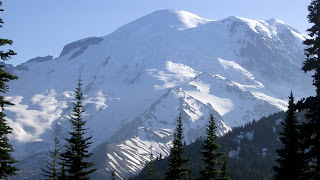
The traverse near the summit might seem kind of pointless on the map, but looking at the summit in this picture I took from the Sunrise area while touring a few days area, you can see how the traverse avoids some steeper terrain (and a tricky bergschrund) by heading toward a saddle, from which the summit is just up a very casual non-glaciated hill:
So skiing from the summit starts off with a ridiculously casual descent almost true north, then starting at around 13,600' a still fairly easy ski, cutting to the skier's right (i.e., east) across the fall line. From a skiing difficultly standpoint, very similar to cutting across Mt Washington's NE Snowfield, toward the lower part of the East Snowfield, when skiing from the summit to Tuckerman Ravine.
The difference though is how I thought at the time that a fall there on the Emmons would be the equivalent of going all the way from the NE Snowfield to Route 16:
Unfortunately, that is exactly what happened to ranger Nick Hall, apparently in the process of loading one of the victims into a Chinook.
RIP ranger Nick, a true hero.


One report claims, "...Claire was the fifth climber in the group but decided not to make the trip with the other four and watched them from a base camp. Williams said Kultgen watched them and until they suddenly disappeared and she made an emergency call." http://goo.gl/TtQFI
ReplyDeleteIs this possible from Camp Shurman or Camp Curtis?
The article you link to makes it sound like they were heading to 8800 feet which would be Curtis.
disappeared and she made an emergency call."
ReplyDelete-- Looking back at both my memories and my pictures from Camp Schurman (the evening before our 2009 summit ski) and just a little ways up from Camp Curtis at Steamboat Prow (from way back in Aug 1999 & Jul 2004), yes, the view is pretty much unobstructed of the entire route to the saddle.
-- However, it's still really far away. To be sure they had fallen into a crevasse and required rescue), she would have needed binoculars, but that too is possible.
re "Wren, 22, and park rangers hiked from 13,700 to 13,200 feet this morning but had to stop because of worsening weather, said Dena Williams, Wren’s aunt. They still must hike about 4,400 feet to reach the base camp, she said."
-- Getting Wren to Camp Curtis would be difficult, since it requires either a rock scramble *up* that she definitely can't do in her condition, or further descending down past Camp Schurman then a nasty little ascent up snow/mud/yuck to Camp Curtis.
-- Plus Camp Curtis doesn't have any facilities, so I suspect their goal is Camp Schurman.
-- If the 4,400' is meant to be cumulative, then that does come pretty close to matching up with the elevation differential between the incident site vs Schurman.