September 2012
Forecast valid until updated
AVALANCHE PROBLEM

list of avalanche problems
|
DANGER
MODERATE where the new snow is wind drifted in the upper elevations
|
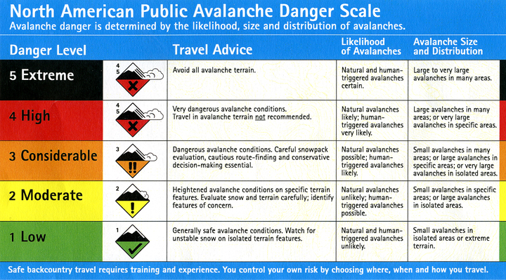
DANGER SCALE

click for danger scale
|

DANGER TREND: The danger is steady. Expect to trigger windslabs. There have been a few new snow point release avalanches to size 1.5 that have traveled 500 feet or more.
WEATHER: As winter approaches, the weather systems coming off the Gulf of Alaska are more organized and intense producing moist coastal air which comes into contact with below freezing air out of the interior and blanketing the mountains with new snow.
TRAVEL ADVISORY: The danger is only in the upper elevations, above 3500 feet. Unsuspecting hikers have been swept away, buried and killed by "termination dust".
AVALANCHE DISCUSSION: The six inches of rainfall in Valdez during the first week of September fell as snow in the upper elevations. There are new snow drifts six to ten feet deep above 4000 feet elevation.
A lot of last winter's exceptionally deep snowfall remains unmelted in the upper elevations. There is still snow along the road over Thompson Pass (2678' elevation). A number of the avalanche start zones and gullies are already smoothed over with old snow. Where old snow remains there is not the surface roughness which holds the season's new snow to the mountains. Also, where the old snow remains, there is less ground surface roughness reducing the runout of early season avalanches.
Post your observations <here>.
Avalanches are sized using the destructive scale <here>.
SNOW:
VALDEZ
|
THOMPSON PASS
| |
24 Hour
|
0"
|
0"
|
September
|
0"
|
0"
|
Season Total
|
0"
|
0"
|
Base
| 0" |
0"
|
CONFIDENCE: Good.
DEFINITIONS:
Snow climate zones:
- Maritime (Coastal) - from the Port of Valdez to Thompson Pass, all waters flowing into Valdez Arm and everything south of Marshall Pass.
- Inter-mountain (Transitional) - between Thompson Pass and Rendezvous Lodge.
- Continental (Interior) - the dry north side of the Chugach (north of 46 Mile, including the Tonsina River).
ELEVATIONS:
Lower - below 1500 feet
Mid - between 1500 and 3000 feet
Upper - above 3000 feet
Mid - between 1500 and 3000 feet
Upper - above 3000 feet

No comments:
Post a Comment